Our Blog

Stories, insights, and discoveries from Canada's water wonders

Niagara Falls
WATERFALLS March 15, 2025 8 min read

Niagara Falls: A Natural Wonder That Never Stops Amazing

Standing at the edge of Niagara Falls, watching 750,000 gallons of water cascade over the precipice every second, you witness one of nature's most powerful displays. But there's far more to this iconic landmark than meets the eye.

The Power Behind the Beauty

Niagara Falls consists of three waterfalls: the American Falls, Bridal Veil Falls, and the famous Horseshoe Falls. Together, they form the highest flow rate of any waterfall in North America, with an average of 85,000 cubic feet of water going over the crest every second during peak daytime tourist hours.

The falls were formed approximately 12,000 years ago during the last ice age. As glaciers retreated, they carved out the Niagara River and created the escarpment over which the water now flows. Over millennia, erosion has caused the falls to recede approximately 7 miles from their original location.

A Hydroelectric Marvel

Beyond its natural beauty, Niagara Falls is a significant source of hydroelectric power. The Sir Adam Beck Generating Stations on the Canadian side produce up to 2,400 megawatts of electricity, providing power to millions of homes and businesses in Ontario.

Water is diverted from the Niagara River above the falls through tunnels and conduits to the power plants. To maintain the falls' visual appeal, international treaties regulate how much water can be diverted, especially during daylight hours in the tourist season.

Best Times to Visit

Each season offers a unique perspective on Niagara Falls. Summer brings warm weather and full water flow, though crowds can be substantial. Winter transforms the falls into a frozen wonderland, with ice formations creating ethereal sculptures, though some attractions close.

Spring and fall provide excellent middle ground — fewer tourists, comfortable temperatures, and spectacular views. April through June sees the highest water volumes as snowmelt from the Great Lakes increases river flow.

Photography Tips

For photographers, the golden hour just after sunrise or before sunset provides magical lighting. The mist creates beautiful rainbows on sunny days — position yourself with the sun at your back for the best rainbow shots.

Night photography offers another dimension as colorful LED lights illuminate the falls. Use a tripod and long exposure to capture the silky texture of the water while maintaining sharpness in the surrounding landscape.

Did You Know?

The name "Niagara" comes from the Iroquois word "Onguiaahra," meaning "The Strait." The falls move upstream at a rate of approximately 1 foot per year due to erosion, though modern flow control has significantly slowed this process.

Whether you're experiencing Niagara Falls for the first or fiftieth time, its raw power and timeless beauty never fail to inspire. This natural wonder reminds us of the incredible forces that have shaped our planet and continue to do so today.

Author

Sarah Mitchell

Lead Photographer & Founder
Moraine Lake
ROCKY MOUNTAINS March 10, 2025 10 min read

Moraine Lake: The Jewel of the Canadian Rockies

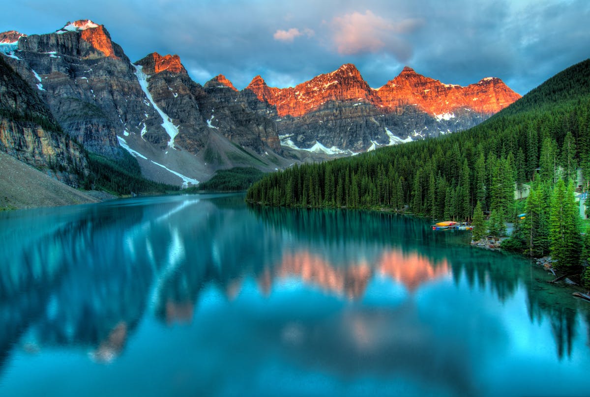
Nestled in the Valley of the Ten Peaks in Banff National Park, Moraine Lake displays a turquoise hue so vivid it seems almost unnatural. This glacially-fed alpine lake has become one of the most photographed locations in Canada — and for good reason.

The Science Behind the Color

Moraine Lake's stunning turquoise color comes from rock flour — finely ground rock particles created by glacial erosion. As glaciers grind against bedrock, they produce these microscopic particles that remain suspended in the meltwater.

When sunlight hits the lake, the rock flour particles absorb longer wavelengths of light (reds and yellows) while reflecting shorter wavelengths (blues and greens). The result is the breathtaking turquoise color that makes the lake famous. The color is most vivid from mid-June through early September when glacial melt is at its peak.

Geography and Formation

Sitting at an elevation of 6,183 feet (1,885 meters), Moraine Lake is fed by glacial meltwater from the Wenkchemna Glacier. The lake reaches a depth of approximately 50 feet and covers about 0.5 square kilometers.

Contrary to its name, the lake wasn't formed by a moraine (glacial debris). Instead, it was created by a large rockfall that dammed the valley. The name came from an early explorer's mistaken belief about its origins, but the designation stuck.

The Valley of the Ten Peaks

The dramatic backdrop of ten mountain peaks rising above the lake creates one of Canada's most iconic vistas. These peaks, which reach heights of over 10,000 feet, were originally named by Samuel Allen using the Stoney Nakoda words for numbers one through ten.

The most prominent peak is Mount Temple at 11,627 feet (3,544 meters), visible on the left side of the classic Moraine Lake view. The indigenous Stoney Nakoda people have deep connections to this landscape, having traveled these valleys for centuries.

Planning Your Visit

Access to Moraine Lake is restricted to shuttle buses during peak season (mid-May through mid-October) due to overwhelming popularity. The parking lot fills by 5:30 AM, so taking the Parks Canada shuttle from Lake Louise is highly recommended.

The road to Moraine Lake closes for winter, typically from mid-October until late May or early June, depending on snow conditions. When open, sunrise provides the calmest conditions and often the best light for photography.

Hiking and Activities

The Rockpile Trail is a short but steep 15-minute hike that leads to a viewpoint offering the classic Moraine Lake panorama — the view that graced the Canadian $20 bill from 1969 to 1979. This is where most iconic photos are taken.

For more adventurous hikers, the Consolation Lakes trail offers a moderate 6-kilometer round trip through forest and boulder fields to pristine alpine lakes. The Larch Valley trail, though challenging, rewards with stunning views and, in late September, golden larch trees.

Photography Tip

The best light occurs in early morning when the lake is calm and the peaks are illuminated by sunrise. Bring a polarizing filter to reduce glare and enhance the turquoise color. The Rockpile viewpoint can be crowded — arrive before 6 AM for the best experience.

Wildlife and Ecology

The area around Moraine Lake is prime grizzly bear habitat. Parks Canada often closes trails when bears are active in the area. Always carry bear spray, make noise while hiking, and follow all wildlife guidelines.

The lake's frigid temperatures (even in summer, rarely exceeding 5°C) mean swimming is not recommended. The cold glacial water, while pristine, can cause hypothermia within minutes.

Moraine Lake represents the quintessential Canadian Rockies experience — a place where geology, ecology, and breathtaking beauty converge. Whether you visit for photography, hiking, or simply to witness one of nature's masterpieces, this alpine gem never disappoints.

Author

David Chen

Environmental Researcher

BC Waterfall
BRITISH COLUMBIA March 5, 2025 12 min read

Hidden Waterfalls of British Columbia: Beyond Niagara

While Niagara Falls claims fame as Canada's most iconic waterfall, British Columbia harbors dozens of spectacular cascades nestled in pristine rainforests and mountain valleys. These hidden gems offer intimate experiences away from tourist crowds.

Shannon Falls: BC's Third Highest

Located just south of Squamish along the Sea-to-Sky Highway, Shannon Falls plunges 335 meters (1,105 feet) down a series of cliffs. This makes it the third-highest waterfall in British Columbia, yet it remains relatively unknown compared to more famous destinations.

The falls are fed by Shannon Creek, which originates in the mountains above. The volume varies dramatically by season — spring snowmelt creates a thundering torrent, while late summer sees a more delicate cascade. A short, accessible trail leads to viewing platforms where you can feel the mist and hear the roar.

Helmcken Falls: A Winter Wonderland

Deep in Wells Gray Provincial Park, Helmcken Falls drops 141 meters (463 feet) into the Murtle River canyon. What makes this waterfall truly special is its winter transformation. As temperatures plummet, spray freezes into a massive cone of ice that can grow up to 60 meters tall.

The falls are fed by the Murtle River, which drains from nearby Murtle Lake. The viewing platform sits at rim level, providing a bird's-eye view into the misty canyon. Summer brings rainbows dancing in the spray, while winter offers the surreal sight of the ice cone growing larger with each passing week.

Brandywine Falls: A Geological Wonder

Just 13 kilometers from Whistler, Brandywine Falls drops 70 meters over a lava cliff into a deep pool below. The waterfall was formed when lava from the eruption of Mount Fee about 10,000 years ago created a resistant cap rock that the creek couldn't easily erode.

A well-maintained trail through old-growth forest leads to multiple viewpoints. The name "Brandywine" comes from a bet between two railway surveyors in the early 1900s — they wagered a bottle of brandy over who could guess the falls' height more accurately.

Della Falls: Canada's Highest

Hidden in Strathcona Provincial Park on Vancouver Island, Della Falls is Canada's tallest waterfall at 440 meters (1,444 feet). Reaching it requires a serious commitment — an 8-kilometer paddle across Great Central Lake followed by a challenging 16-kilometer hike through old-growth rainforest.

The effort rewards adventurers with one of BC's most spectacular sights. Della Creek plunges down the granite face of Mount Colonel Foster in three main drops. Few people make the journey, ensuring an intimate experience with this natural wonder.

Hiking Safety

BC waterfalls often require hiking through bear country. Always carry bear spray, make noise on trails, and never hike alone. Check trail conditions before departing — spring runoff can make creek crossings dangerous, and winter ice creates serious hazards.

Proxy Falls: Ancient Forest Guardian

In Manning Provincial Park, Proxy Falls cascades through ancient hemlock and cedar forest. While not the tallest at 26 meters, its setting in old-growth rainforest creates an enchanting atmosphere. Massive trees draped in moss surround the falls, and the soft forest floor absorbs sound, creating an almost sacred silence broken only by rushing water.

Best Seasons for Waterfall Viewing

Spring (May-June) offers the highest flow rates as mountain snowpack melts. Waterfalls rage with maximum power, though trails can be muddy and creek crossings hazardous. This is the time for dramatic photography and feeling the raw power of nature.

Summer (July-August) brings lower flows but comfortable hiking conditions. Waterfalls are still impressive, and you can get closer without being drenched in spray. Wildlife is more active, and wildflowers bloom along trails.

Fall (September-October) sees moderate flows enhanced by autumn colors. Fewer crowds and crisp air make this an ideal time for experienced hikers. Winter transforms accessible waterfalls like Brandywine and Shannon into ice sculptures, though many backcountry falls become unreachable.

Conservation and Respect

These waterfalls flow through ecosystems that have existed for thousands of years. Stay on designated trails to prevent erosion and protect fragile plant life. Pack out all trash, respect wildlife, and remember that these landscapes are both recreation areas and habitat for countless species.

Many waterfalls are sacred sites to Indigenous peoples. Approach with respect and leave offerings undisturbed. Learn about the First Nations whose traditional territories you're visiting — their stories and connection to these places span millennia.

British Columbia's hidden waterfalls offer something Niagara never can — solitude, wilderness, and a sense of discovery. Whether you're seeking a roadside wonder or a multi-day backcountry adventure, BC's cascades await those willing to venture beyond the well-known destinations.

Author

Emily Tremblay

Content Director

Northern Lake
NORTHERN CANADA February 28, 2025 9 min read

Northern Lakes: Where Silence Meets Wilderness

Canada's northern lakes exist in a realm apart — vast, pristine, and largely untouched by human development. These waters hold stories written in ice and stone, witnessed only by caribou, wolves, and the occasional adventurer brave enough to venture beyond the treeline.

The Character of Northern Waters

Northern Canadian lakes differ fundamentally from their southern counterparts. Ice-covered for eight to nine months annually, these waters remain frigid even in summer. The short growing season means limited aquatic vegetation, resulting in crystal-clear water that reveals rocky bottoms dozens of feet below the surface.

The water itself tells a story of geological time. Many northern lakes fill depressions carved by glaciers during the last ice age. Some sit on ancient bedrock over 2.5 billion years old — among the oldest exposed rock on Earth. The Canadian Shield's granite bones lie bare here, scraped clean by ice sheets kilometers thick.

Great Slave Lake: The North's Giant

At 614 meters (2,014 feet), Great Slave Lake is the deepest lake in North America. Its waters are so cold that even summer surface temperatures rarely exceed 10°C, while depths remain near freezing year-round. The lake covers 27,200 square kilometers — roughly the size of Belgium.

The lake's name comes from the Slavey (Dene) people who have lived along its shores for millennia. Today, Yellowknife, the capital of Northwest Territories, sits on its northern shore. The lake serves as a highway when frozen — ice roads carry supplies to remote communities from December through April.

Great Bear Lake: Arctic Isolation

Canada's largest lake entirely within its borders, Great Bear Lake sprawls across 31,153 square kilometers north of the Arctic Circle. Only two tiny communities exist on its shores — a testament to the extreme remoteness and harsh climate.

The lake's water is among the purest on Earth. With virtually no human development in its watershed and temperatures too cold for most pollutants to degrade, the lake remains in near-pristine condition. Indigenous Dene communities consider it sacred, and scientific research confirms it as an irreplaceable ecological treasure.

Life in the Extreme

Despite harsh conditions, northern lakes support diverse ecosystems adapted to cold and darkness. Lake trout grow slowly but reach enormous sizes — specimens over 30 kilograms are caught regularly. Arctic char, whitefish, and northern pike complete the fish community.

Caribou herds migrate past northern lakes in spring and fall, sometimes numbering in the thousands. Wolves follow the caribou, while grizzly bears fish the lake outlets. Waterbirds nest on islands during the brief summer, then flee south before winter's return. Loons' haunting calls echo across still waters on June's midnight sun.

Extreme Environment

Visiting northern lakes requires serious preparation. Weather changes rapidly, temperatures drop dramatically at night even in summer, and rescue is difficult or impossible. Only experienced wilderness travelers should venture to these remote waters, and never alone.

The Indigenous Connection

For Dene, Inuit, and other Indigenous peoples, northern lakes are far more than scenic destinations. These waters provide food, transportation, and spiritual connection. Stories passed down through generations map the lakes' features, explain their formation, and encode survival knowledge essential in this unforgiving environment.

Many northern lakes have Indigenous names that describe their characteristics or historical significance. Learning and using these names honors the peoples who have known these waters for thousands of years. Their traditional ecological knowledge offers insights science is only beginning to appreciate.

Climate Change at the Frontline

Northern lakes are changing faster than lakes anywhere else on Earth. Ice-free periods are lengthening, winter ice thickness is decreasing, and water temperatures are rising. These changes ripple through ecosystems evolved for consistent cold.

Scientists monitor northern lakes as climate sentinels — early warning systems for global changes. The data reveals worrying trends: permafrost thaw releases mercury into lake waters, changing ice conditions threaten ice road transportation, and shifts in fish populations affect communities dependent on traditional harvests.

Experiencing the Northern Lakes

Few people will ever stand on the shore of Great Bear Lake or paddle the bays of Great Slave. Reaching these remote waters requires float planes, boats, or winter ice roads. Guided expeditions offer the safest way to experience these landscapes, with local Indigenous guides providing irreplaceable knowledge and context.

For those who make the journey, the reward is profound. The silence is complete — no traffic, no aircraft, no human sounds beyond your own breathing. The light is different, sharp and clear. The water's purity makes you reconsider what "clean" means. And the vastness puts human concerns in humbling perspective.

Northern lakes remind us that wilderness still exists — not as preserved parks visited on weekends, but as living, functioning ecosystems largely beyond human influence. They represent what Earth was like before cities, before agriculture, before our species reshaped the planet. That alone makes them invaluable, and worth protecting for generations yet to come.

Author

David Chen

Environmental Researcher

Aurora over lake
PHOTOGRAPHY February 20, 2025 11 min read

Great Slave Lake Under Aurora: A Photographer's Paradise

When the northern lights dance above Great Slave Lake's dark waters, photographers witness one of nature's most spectacular phenomena. The combination of pristine lake reflections and aurora borealis creates images that captivate viewers worldwide.

Understanding the Aurora Borealis

The northern lights occur when charged particles from the sun collide with gases in Earth's atmosphere. These collisions produce light — green from oxygen at lower altitudes, red from oxygen at higher altitudes, and blue or purple from nitrogen. The aurora appears in an oval around the magnetic north pole, making northern Canada a prime viewing location.

Yellowknife, on Great Slave Lake's northern shore, sits directly beneath the aurora oval. The city promotes itself as the "Aurora Capital of North America" with good reason — clear, dark skies and optimal latitude provide aurora visibility over 240 nights per year.

Why Great Slave Lake Is Special

The lake's vast expanse creates a natural mirror for aurora photography. When conditions align — calm winds, clear skies, strong aurora — the lights reflect perfectly in the dark water, creating symmetrical compositions that double the visual impact.

Great Slave Lake's size prevents light pollution from reaching many shoreline locations. Even near Yellowknife, you can find dark sky sites within short drives. The lake's northern latitude (62°N) places it in the aurora sweet spot — far enough north for frequent displays, but not so far that infrastructure becomes impractical.

Best Times for Aurora Photography

Aurora season runs from late August through April. September-October and March-April offer the best combination of aurora activity and manageable temperatures. Midwinter (December-February) brings the coldest weather but also the longest nights and often the strongest displays.

New moon periods provide the darkest skies, though strong aurora can overcome moonlight. Check solar activity forecasts — the KP index predicts aurora strength. KP 3-4 produces good displays at Great Slave Lake; KP 5+ creates spectacular shows.

Camera Settings for Aurora

  • ISO: Start at 3200, adjust based on aurora brightness
  • Aperture: f/2.8 or wider if possible
  • Shutter Speed: 5-15 seconds (shorter for fast-moving aurora)
  • Focus: Manual focus on infinity (test and mark your lens)
  • White Balance: 3500-4000K, or shoot RAW and adjust later

Composition Techniques

Include foreground elements for scale and interest — ice formations, snow-covered trees, or the lake's rocky shore work well. Position these elements in the lower third of your frame, allowing the aurora and its reflection to dominate.

For reflection shots, the water must be calm and ice-free (typically September-October or May-June). Even small waves destroy perfect reflections. Scout locations during daylight to plan compositions and identify hazards invisible in darkness.

Surviving the Cold

Winter aurora photography at Great Slave Lake means extreme cold — temperatures from -20°C to -40°C are normal. Layered clothing, insulated boots rated to -50°C, and hand warmers are essential. Camera batteries drain quickly in cold; keep spares in inside pockets warmed by body heat.

Condensation is a serious concern. When bringing cold cameras indoors, seal them in plastic bags before entering. Let them warm slowly to room temperature before opening bags — this prevents moisture from condensing on sensors and electronics.

The Waiting Game

Aurora photography requires patience. You might wait hours in cold darkness before the lights appear, or they might never show despite favorable forecasts. Experienced photographers bring warm shelters, hot drinks, and entertainment for long waits.

When aurora appears, conditions can change rapidly. Be ready to shoot instantly — the best displays sometimes last only minutes. But they can also persist for hours, morphing from subtle green bands to explosive multicolored curtains that fill the sky.

Post-Processing Considerations

Shoot RAW format for maximum editing flexibility. Aurora colors often appear more vivid to cameras than to human eyes — our eyes adapt to darkness, losing some color sensitivity. Light processing brings images closer to what we see, while heavy processing can create unrealistic results.

Adjust white balance to achieve accurate colors — aurora green tends toward yellow-green, not the intense lime green some processed images show. Reduce noise carefully, as aggressive noise reduction can eliminate fine aurora details. Enhance the Milky Way if visible, and bring up foreground details without overpowering the aurora.

Respecting the Environment

Great Slave Lake's shores are fragile ecosystems. Stay on established paths, pack out all trash, and respect any closures or restricted areas. Indigenous communities live along the lake — respect private property and cultural sites.

Consider the impact of sharing locations. While photographers naturally want to share beautiful places, overcrowding can damage fragile environments and disturb wildlife. Share responsibly, emphasizing the need for proper preparation and respect.

Photographing aurora over Great Slave Lake combines technical challenge, physical endurance, and pure awe. When you nail the shot — perfect reflection, strong aurora, compelling foreground — the cold, fatigue, and frustration fade. What remains is an image capturing one of Earth's most magnificent phenomena, and memories of standing beneath dancing lights in one of the world's most remote and beautiful places.

Author

Sarah Mitchell

Lead Photographer & Founder